Embark on a comprehensive journey into Integrated Crisis Mapping and fortify your crisis communication strategies. This guide explores essential communication examples, offering insights, tips, and real-world applications. Elevate your crisis response readiness by harnessing the power of integrated mapping to navigate uncertainties with precision. Communication examples throughout illuminate effective strategies for optimal crisis management.
What is Integrated Crisis Mapping?
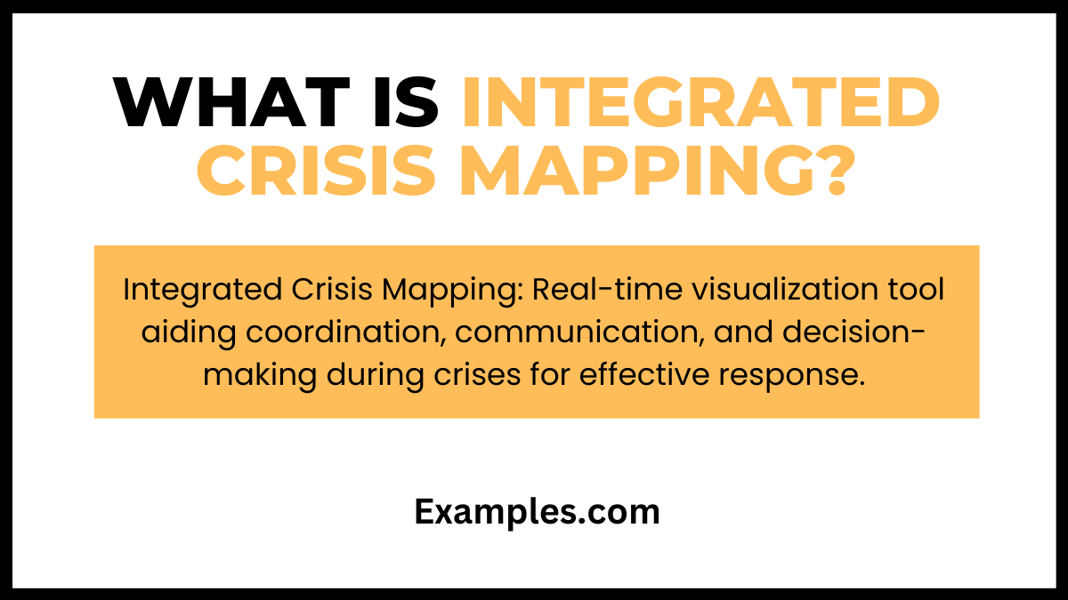
Integrated Crisis Mapping refers to the utilization of various data sources, including real-time information from social media, traditional news, and geospatial data, to create dynamic and comprehensive maps during crises. These maps aid in visualizing the evolving situation, identifying affected areas, and coordinating response efforts effectively. By integrating diverse data streams into a unified mapping platform, organizations gain a holistic view, enhancing communication, decision-making, and overall crisis management.
20 Integrated Crisis Mapping Examples
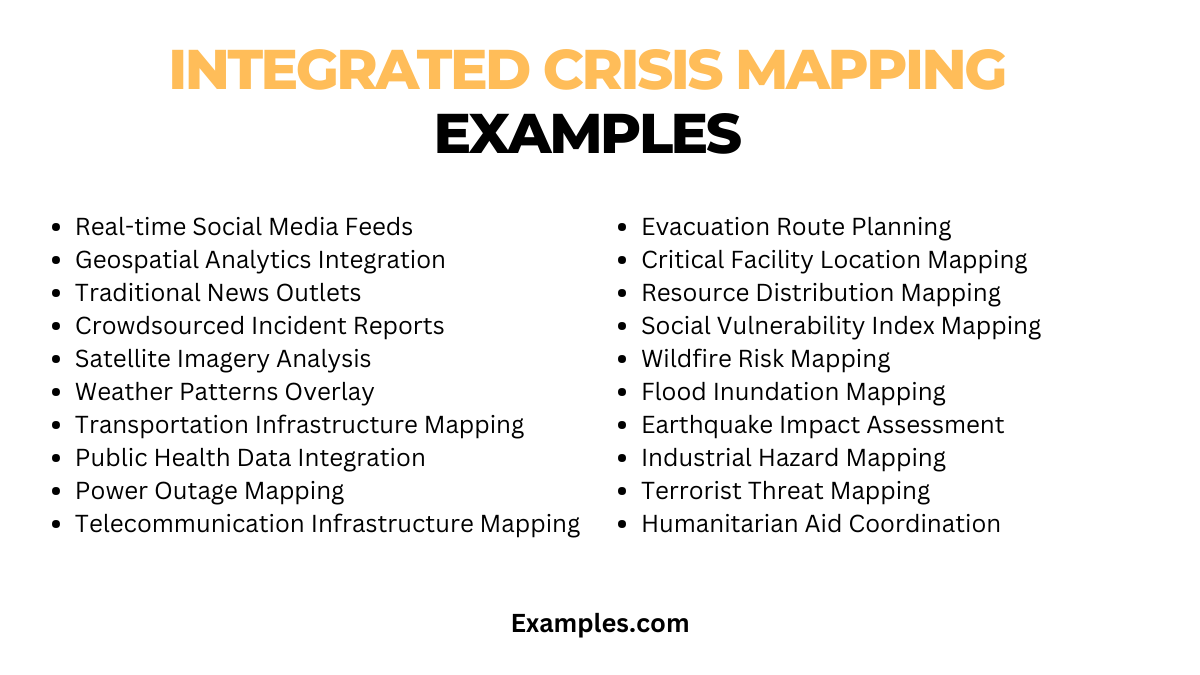
Integrated Crisis Mapping employs diverse data sources for comprehensive crisis visualization:
- Real-time Social Media Feeds: Monitor platforms for user-generated crisis data, enhancing situational awareness.
- Geospatial Analytics Integration: Combine geographic data with crisis information for precise mapping and targeted response.
- Traditional News Outlets: Integrate news reports for verified crisis updates and reliable information dissemination.
- Crowdsourced Incident Reports: Utilize public input for real-time incident reporting and community-driven crisis mapping.
- Satellite Imagery Analysis: Incorporate satellite data for accurate damage assessment and resource allocation.
- Weather Patterns Overlay: Integrate weather data to anticipate and respond to natural disasters effectively.
- Transportation Infrastructure Mapping: Visualize transportation networks to plan and optimize crisis response routes.
- Public Health Data Integration: Combine health-related data to track and manage disease outbreaks during crises.
- Power Outage Mapping: Monitor and map power outages for prioritized response in affected areas.
- Telecommunication Infrastructure Mapping: Visualize communication infrastructure to ensure connectivity during crises.
- Evacuation Route Planning: Plan and communicate evacuation routes through dynamic mapping for public safety.
- Critical Facility Location Mapping: Identify and map critical facilities to prioritize protection and resource allocation.
- Resource Distribution Mapping: Optimize resource distribution by mapping available resources and demand.
- Social Vulnerability Index Mapping: Utilize social vulnerability indices to prioritize aid in disadvantaged areas.
- Wildfire Risk Mapping: Predict and map wildfire risks, aiding in prevention and early response.
- Flood Inundation Mapping: Visualize potential flood areas to plan and execute timely evacuation measures.
- Earthquake Impact Assessment: Map earthquake impact zones for efficient emergency response and recovery.
- Industrial Hazard Mapping: Identify and map areas prone to industrial hazards, ensuring safety measures are in place.
- Terrorist Threat Mapping: Monitor and map potential terrorist threats to enhance security preparedness.
- Humanitarian Aid Coordination: Facilitate coordination by mapping areas in need and optimizing humanitarian aid delivery.
Integrated Crisis Mapping Examples for Students
For students, Integrated Crisis Mapping serves as an educational tool, fostering awareness and preparedness. It employs user-friendly interfaces and real-world scenarios to enhance understanding of crisis management.
- Campus Emergency Drill Mapping: Conduct emergency drills on campus, mapping evacuation routes and safe zones for students’ safety.
- Global Disaster Response Simulation: Engage students in a virtual global disaster simulation, using crisis mapping to coordinate international relief efforts.
- Community Engagement Mapping Project: Task students with mapping local community vulnerabilities, encouraging civic engagement and proactive crisis planning.
- Public Health Crisis Scenario Mapping: Simulate public health crises, allowing students to map disease spread, healthcare resources, and response strategies.
- Social Media Crisis Analysis: Guide students in analyzing crisis communication on social media through mapping, emphasizing the role of digital information.
Integrated Crisis Mapping Examples for Employees
In the workplace, Integrated Crisis Mapping empowers employees with tools for effective crisis response. It enables real-time collaboration, ensuring a coordinated and swift reaction to crises.
- Office Evacuation Mapping Workshop: Conduct workshops for employees to map office evacuation routes, fostering a proactive approach to workplace safety.
- Supply Chain Disruption Response Mapping: Train employees to map supply chain disruptions, enabling swift adjustments and maintaining operational continuity.
- Telecommuting Crisis Preparedness: Implement crisis mapping for telecommuting scenarios, ensuring employees are equipped to handle remote work during crises.
- Employee Wellness Check Mapping: Utilize mapping tools to conduct wellness checks on employees during crises, promoting a supportive and caring work environment.
- Internal Communication Crisis Mapping: Establish crisis communication maps within the organization, facilitating clear internal communication channels and real-time updates.
Why is Integrated Crisis Mapping Important?
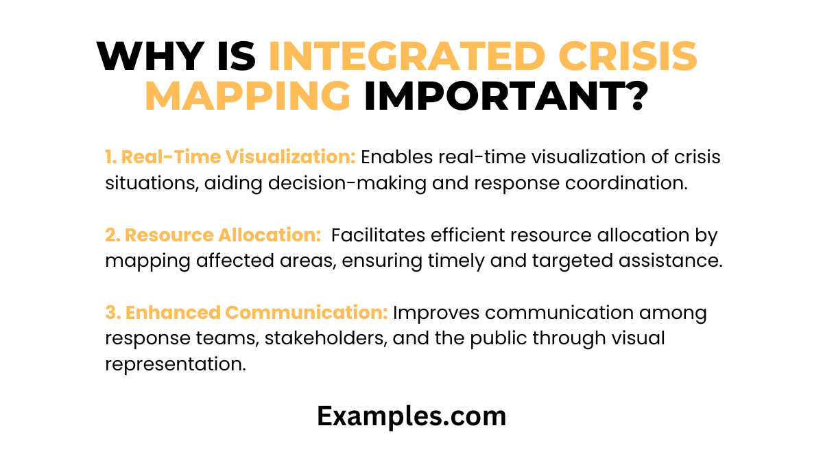
Integrated Crisis Mapping plays a crucial role in modern crisis management, offering a visual and collaborative approach. Its importance stems from:
- Real-Time Visualization: Enables real-time visualization of crisis situations, aiding decision-making and response coordination.
- Resource Allocation: Facilitates efficient resource allocation by mapping affected areas, ensuring timely and targeted assistance.
- Enhanced Communication: Improves communication among response teams, stakeholders, and the public through visual representation.
- Preparedness Training: Supports preparedness training by simulating various crisis scenarios, enhancing readiness.
What are the Stages of Integrated Crisis Mapping?
The implementation of Integrated Crisis Mapping involves several stages:
- Planning: Define objectives, identify stakeholders, and plan the scope of crisis mapping initiatives.
- Data Collection: Gather relevant data, including geographical, demographic, and crisis-specific information.
- Mapping Platform Selection: Choose a suitable mapping platform based on the nature of the crisis and organizational needs.
- Visualization: Map the collected data to create visual representations of the crisis, considering factors like severity, affected areas, and available resources.
- Collaboration: Foster collaboration among response teams, encouraging them to contribute real-time data and insights to the crisis map.
- Analysis: Analyze the mapped data to identify trends, assess impacts, and make informed decisions for crisis response.
- Communication: Use the crisis map as a communication tool to share updates with stakeholders, ensuring transparency.
What are the Benefits of Integrated Crisis Mapping?
Integrated Crisis Mapping offers numerous benefits in crisis management:
- Enhanced Situational Awareness: Provides a clear and comprehensive view of the crisis, improving situational awareness for better decision-making.
- Improved Coordination: Facilitates coordination among response teams, reducing response time and enhancing overall effectiveness.
- Resource Optimization: Enables efficient allocation of resources by identifying critical areas and needs through mapping.
- Effective Communication: Enhances communication through visual representation, making complex information accessible to a broader audience.
- Training and Preparedness: Supports training and preparedness efforts by simulating crises, allowing teams to practice and refine their response strategies.
- Community Engagement: Involves the community in crisis mapping initiatives, fostering a sense of shared responsibility and empowering individuals.
- Continuous Improvement: Allows for continuous improvement by analyzing past crisis maps, identifying areas for enhancement, and refining response strategies.
In conclusion, Integrated Crisis Mapping emerges as a pivotal tool in crisis management, offering real-time visualization, collaboration, and data-driven decision-making. By exploring diverse examples and stages, this comprehensive guide underscores its significance. From enhancing situational awareness to fostering effective communication, Integrated Crisis Mapping proves indispensable for navigating the complexities of crises and ensuring a resilient and coordinated response.