2
Value of Spatial Information
Geographic location is a fundamental reference point in the
physical world, one that grows more critical as enterprise
business systems evolve to more accurately reflect real-
world circumstances.
Companies and organizations have long used Geographic
Information Systems (GIS) to manage business; gathering
and analyzing data associated with geographic locations
of resources, and with geographic areas of interest. Orga-
nizations of all types are now moving to integrate their
GIS systems and their enterprise information technology
systems to obtain even greater value.
Today’s GIS systems solutions are becoming ever more
flexible, dynamic, standards-based enterprise-wide systems.
Organizations are acting to ‘spatially enable’ a wide range
of enterprise applications, and to integrate them, so they
can exchange broader and deeper information. Users
can now gain access to comprehensive location informa-
tion important to their organizations, to help them manage
better.
GIS with enterprise applications
GIS users increasingly access networked GIS geospatial
data and apply analytical capabilities from server-based
solutions, utilizing service-oriented architectures (SOAs) and
Web controls. This technology dynamically combines GIS
and enterprise applications in several ways and provides
many direct benefits:
• Richer analytics – enables better business decisions.
• Improved visualization – maps location of strategic
assets.
• Improved understanding of physical relationships, and
proximity between resources.
• Deeper resource location knowledge over time -- helps
improve resource location awareness, adding visibility to
their movements through geographic areas of interest. .
• Extended modeling – analyzes and visualizes geospatial
patterns to help predict and prepare for future conditions.
Spatial Services solutions for Asset Mangement
The capabilities associated with managing location infor-
mation may be applied to assets as well, to identify them for
inspection, maintenance and repair. Location and proximity
can be factored into planning and executing work, thus
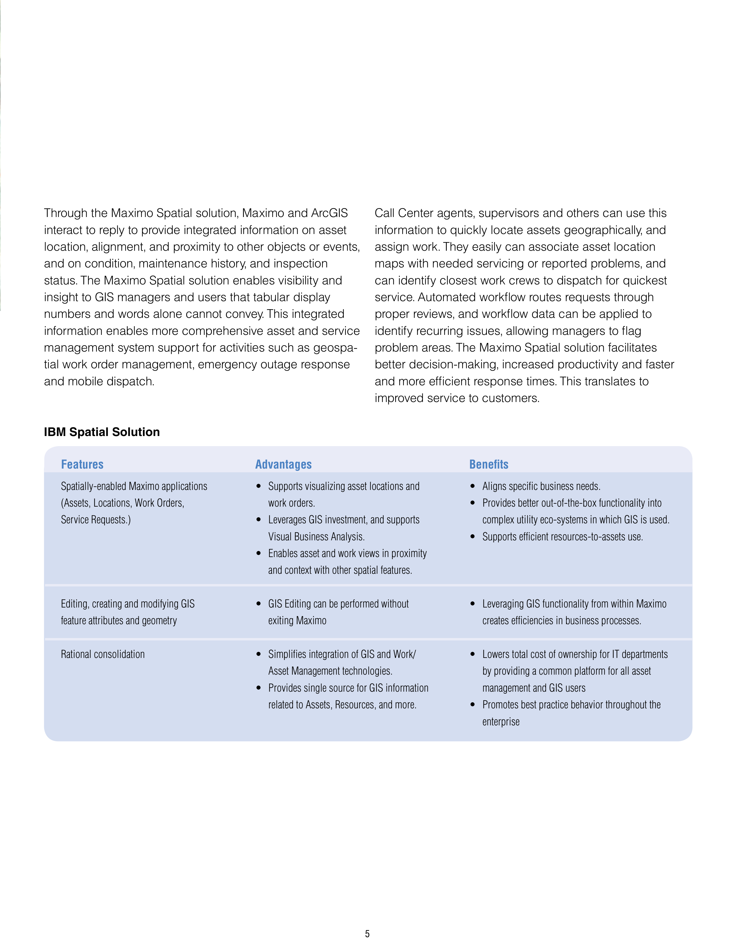
helping scheduling decisions. Call center agents can
pinpoint trouble locations rapidly, and can initiate work
requests based on crew availability and proximity. Decision-
makers draw from GIS /Asset management integration to
facilitate investment planning, and to conduct other mission
critical analyses.
Implementing an integrated Asset Management and GIS
solution is a complex, enterprise-wide endeavor, and
IBM has the expertise to assist you. IBM Spatial Services
consultants will work with you to enhance the value of an
array of Spatial Solutions, including our own Maximo Spatial
solution.
IBM Spatial Services consultants are trained and experi-
enced with ESRI
®
ArcGIS
®
products, and they will help you
determine the optimum configuration for your system, to
assure you get the highest output and value. Our consul-
tants provide industry-leading information technology
knowledge, project management and systems integra-
tion expertise. They apply this knowledge via our proven
tools and methodologies, delivering complex, end-to-end
solutions.